
A platform for land use and land cover data integration and trajectory analysis
by Fabiana Zioti, Karine R.Ferreira, Gilberto R.Queiroz, Alana K.Neves, Felipe M.Carlos, Felipe C.Souza, Lorena A.Santos and Rolf E.O.Simoes
National Institute for Space Research (INPE), Avenida dos Astronautas, 1758, Jardim da Granja, Sao Jose dos Campos, SP 12227-010, Brazil
DOI: https://doi.org/10.1016/j.jag.2021.102655
Publisher: ScienceDirect | Published: 18 December 2021.
Abstract
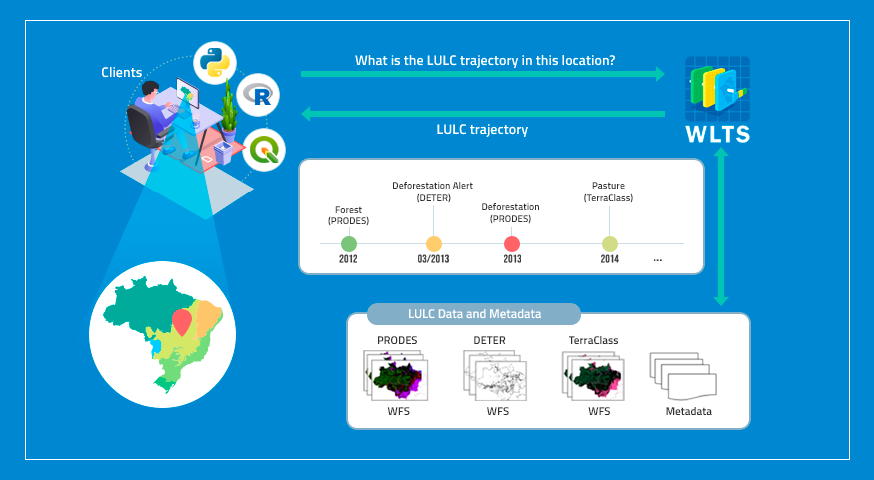
Information on land use and land cover (LULC) is essential to support governments in making decisions about the impact of human activities on the environment, planning the use of natural resources, conserving biodiversity, and monitoring climate change. Nowadays, different initiatives systematically produce information on LULC dynamics, on global, national, and regional scales. Examples of open and global LULC data products are Global Land-cover Classification with a Fine Classification System, Copernicus Global Land Service, and Global Land Cover by European Space Agency (ESA). At the national and regional level in Brazil, we can cite the data sets produced by PRODES, TerraClass, MapBiomas, and IBGE. Although these initiatives provide rich collections of open LULC maps, there is still a gap in tools that facilitate the integration of these data sets. The integrated analysis of these collections requires considerable effort by researchers who have to download, organize and harmonize them in their local computers, facing with different spatiotemporal resolutions and classification systems containing distinct class numbers, names and meanings. Besides that, these collections are distributed in different data formats through files or web services. To minimize these efforts, we propose a platform that allows users to access LULC collections from distinct sources, map their distinct classification systems, and retrieve LULC trajectories associated with spatial locations by integrating these collections. Besides the platform architecture description, this paper presents a case study that demonstrates its use in the integration and analysis.
Keywords: Land use and land cover trajectory, Data integration and analysis
© This is an open access article distributed under the Creative Commons Attribution License which permits unrestricted use, distribution, and reproduction in any medium, provided the original work is properly cited
Share and Cite
Zioti, F.; Ferreira, K. R.; Queiroz, G. R.; Neves, A. K.; Carlos, F. M.; Souza, F. C.; Santos, L. A.; Simoes, R. E. O. A platform for land use and land cover data integration and trajectory analysis. International Journal of Applied Earth Observation and Geoinformation. V 106, P 102655, Feb 2022.