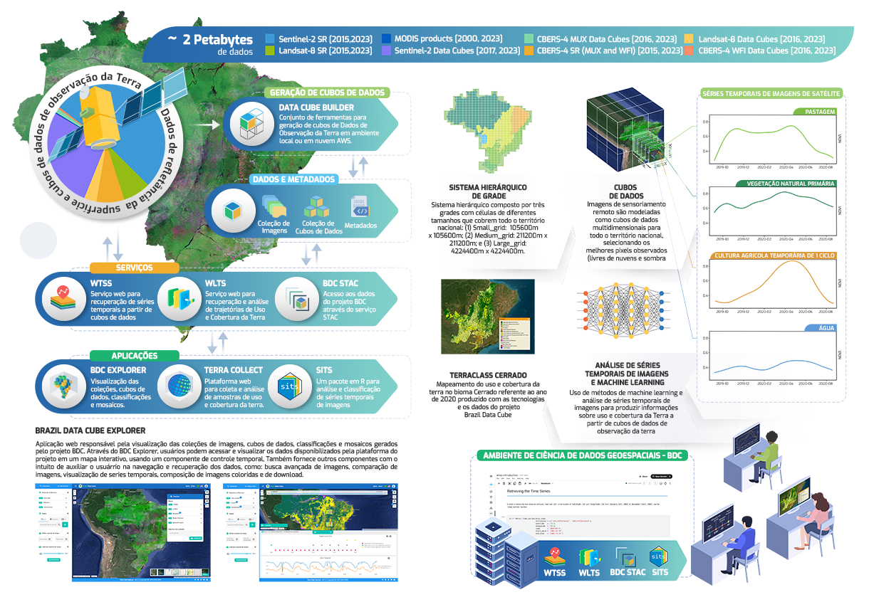
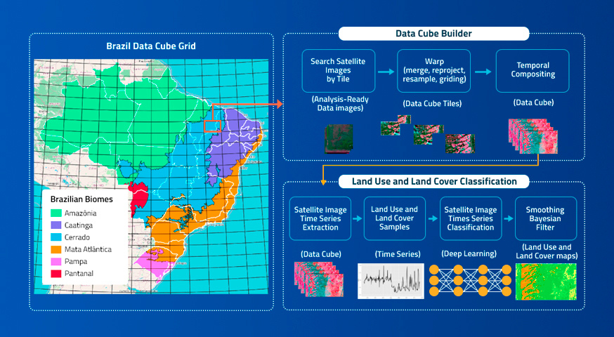
Brazil Data Cube is a research, development and technological innovation project of the National Institute for Space Research (INPE), Brazil. It is producing data sets from big volumes of medium-resolution remote sensing images for the entire national territory and developing a computational platform to process and analyze these data sets using artificial intelligence, machine learning and image time series analysis.
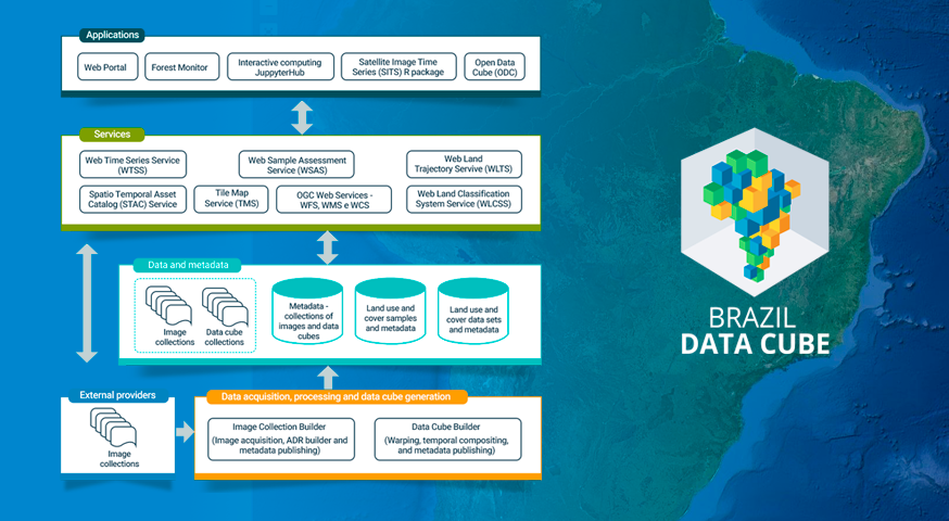
The data sets produced in the BDC project include collections of analysis-ready data (ARD), multidimensional data cubes and mosaics from images of the CBERS-4/4A, Sentinel-2 and Landsat-8 satellites. The computational platform is composed of web services, software applications and iterative computing environments. Using artificial intelligence, machine learning, and image time series analysis, land use and land cover maps are being produced from these data cubes.
Brazil Data Cube is part of the “Environmental Monitoring of Brazilian Biomes project“, funded by the Amazon Fund through the financial collaboration of the Brazilian Development Bank (BNDES) and the Foundation for Science, Technology and Space Applications (FUNCATE) no. 17.2.0536.1 .
Brazil Data Cube Platform
The Brazil Data Cube project has four main objectives:

Brazil Data Cube project reference paper
by Karine R. Ferreira,Gilberto R. Queiroz,Lubia Vinhas,Rennan F. B. Marujo,Rolf E. O. Simoes,Michelle C. A. Picoli,Gilberto Camara,Ricardo Cartaxo,Vitor C. F. Gomes,Lorena A. Santos,Alber H. Sanchez,Jeferson S. Arcanjo,José Guilherme Fronza,Carlos Alberto Noronha,Raphael W. Costa,Matheus C. Zaglia,Fabiana Zioti,Thales S. Korting,Anderson R. Soares,Michel E. D. Chaves andLeila M. G. Fonseca Earth Observation and Geoinformatics Division, National Institute for Space Research …
Project activity report
by Abner Ernani dos Anjos, Alana Kasahara Neves, Alber Hamersson Sánchez Ipia, Carlos Alberto Ferreira de Noronha, Claudinei de Camargo, Fabiana Zioti, Felipe Carvalho de Souza, Felipe Menino Carlos, Gabriel Sansigolo, Gilberto Ribeiro de Queiroz, Jeferson de Souza Arcanjo, Karine Reis Ferreira Gomes, Lorena Alves dos Santos, Luciana Mamede dos Santos, Raphael Willian da Costa, Rennan …
Continue reading “Brazil Data Cube project activity report – January 2020 to May 2021”
Associated publications
by Karine Reis Ferreira, Gilberto Ribeiro de Queiroz Instituto Nacional de Pesquisas Espaciais (INPE), São José dos Campos, SP, Brasil. DOI: http://dx.doi.org/10.5380/atoz.v10i3.81966 Publisher: Web magazine AtoZ | Published: 4 September 2021 Abstract Dr. Karine Reis Ferreira and Dr. Gilberto Ribeiro de Queiroz from Instituto Nacional de Pesquisas Espaciais (INPE) answers questions about big data technology and artificial intelligence, …
Continue reading “Measuring Brazil from space: and artificial intelligence technologies”