
An Unsupervised Segmentation Method For Remote Sensing Imagery Based On Conditional Random Fields
by A. R. Soares; T. S. Körting; L. M. G. Fonseca; A. K. Neves
Coordination of Earth Observation (OBT) – Brazil’s National Institute for Space Research (INPE) Av. dos Astronautas, São José dos Campos – SP, Brazil
DOI: https://doi.org/10.1109/LAGIRS48042.2020.9165623
Publisher: IEEE | Published: 12 August 2020
Published in: 2020 IEEE Latin American GRSS & ISPRS Remote Sensing Conference (LAGIRS)
Abstract
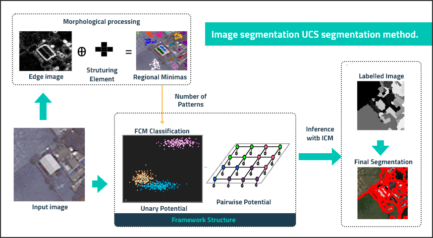
Segmentation is a fundamental problem in image processing and a common operation in Remote Sensing, which has been widely used especially in Geographic Object-Based Image Analysis (GEOBIA). In this paper, we propose a new unsupervised segmentation algorithm based on the Conditional Random Fields (CRF) theory. The method relies on two levels of information: (1) that comes from an unsupervised classification with Fuzzy C-Means algorithm; (2) the 8-connected neighbourhood of a pixel. The algorithm was tested on a WorldView-2 multispectral image, with 2m of spatial resolution. Results were evaluated using 6 quality measures, and their performance was compared with other image segmentation algorithms that are usually applied by the Remote Sensing community. Results indicate that the proposed algorithm achieved superior overall performance when compared others, despite some over-segmentation.
Keywords: Image segmentation, Remote Sensing, Conditional Random Fields, GEOBIA