
CBERS data cubes for land use and land cover mapping in the Brazilian Cerrado agricultural belt
by Michel E. D. Chaves, Anderson R. Soares, Ieda D. Sanches and José G. Fronza
Earth Observation and Geoinformatics Division, National Institute for Space Research (INPE), Avenida dos Astronautas, 1758, Jardim da Granja, Sao Jose dos Campos, SP 12227-010, Brazil
DOI: https://doi.org/10.1080/01431161.2021.1978584
Publisher: International Journal of Remote Sensing | Published: 30 Sep 2021
Abstract
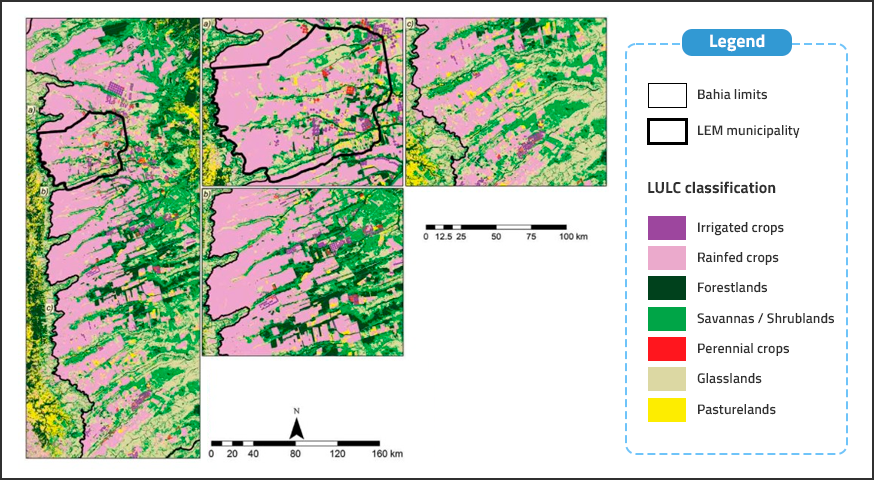
The agricultural frontier expansion in the Cerrado biome made Brazil a leader in commodity exports and is changing its landscape. Hence, efforts to accurate land use and land cover (LULC) monitoring in this region are strategic, due to its role in Brazil’s food, environmental, and economic security policy. Thinking on planning and technical sovereignty in the spatial sector, the China–Brazil Earth Resources Satellite (CBERS) Program was launched to provide useful data for decision-makers to manage the Brazilian territory independently of external policies. Their data, especially from CBERS-4 Wide-Field Imager (CBERS-4/WFI), are largely applied in deforestation monitoring by remote sensing specialists but less applied than data from other image providers for machine learning-based LULC mapping due to the small number of spectral bands and limitations related to clouds and shadows detection. However, with advances in orbital data analysis, data cubes enabled storing and accessing large spatio-temporal analysis-ready data. Within this scope, the Brazil Data Cube Project (BDC) creates multidimensional data cubes from orbital sensors’ data for all Brazilian territory. We applied BDC CBERS-4/WFI data cubes to generate LULC classifications for the Extremo Oeste Baiano agricultural belt correspondent to the 2017/2018 and 2019/2020 harvest periods, at two levels of detail: broad and crop type, incorporating ground truth samples, crop calendar knowledge, and vegetation indices to a dense time series analysis approach. Overall Accuracies were equal to 0.87 and 0.89 for broad, and 0.91 and 0.94 for crop type classifications. The results indicate CBERS-4/WFI data cubes as a useful tool for improving crop monitoring in the Cerrado biome based on machine learning.
Keywords: